SIOUX FALLS, S.D. (KELO.com) — The first major snowstorm of the season is expected to deliver feet of snow in the highest elevations, while powerful winds associated with the storm could produce blizzard conditions.
The northern Rockies will have intense snowfall throughout Monday, making travel extremely difficult amid the unseasonably low temperatures.
The first major snowstorm of the season continued to unfold across parts of the Intermountain West on Tuesday as forecasters said the robust storm system was impacting areas from Montana to Arizona.
Winter storm warnings were in place for parts of Wyoming, Montana, Colorado, Utah and Idaho. Snow began falling across parts of Nevada, Idaho and Montana as early as Monday morning. Some parts of Montana had already reported more than a foot of snow as of late Monday night, with as much as 20 inches falling near the community of Pony in the southwestern part of the state.

Winter storm warnings (dark blue) and winter storm advisories (gray) were in effect on Tuesday, Oct. 12, 2021 across parts of the Intermountain West.
Across the highest elevations of Montana, Idaho, Wyoming and Colorado, snow may be measured in feet rather than inches as an AccuWeather Local StormMax of 40 inches of snow is possible through Wednesday. Places along the Front Range like Torrington, Wyoming, Fort Collins, Colorado, and perhaps even the western suburbs of Denver are expected to stay just warm enough for precipitation to fall as liquid; however, there’s a small chance the first flakes of the season mix in.
Some of the first rain and snow showers associated with the storm were reported Sunday in the Pacific Northwest. While some beneficial rain and snow fell across Washington and Oregon as the weekend ended, the most impactful wintry weather will continue to cross the Intermountain West through midweek.

The storm will continue to gather strength through Tuesday evening, as snowfall rates are forecast to pick up across the northern Rockies. Travel conditions across the mountainous terrain of Idaho, western Montana and northwestern Wyoming can quickly become hazardous as snowfall rates of an inch or more per hour can lead to whiteout conditions.
This includes the scenic areas in and around Yellowstone National Park. Snow is expected to fall through much of Tuesday, making travel extremely difficult, if not impossible. Mountainous regions just northwest of the national park have already reported snowfall amounts nearing one foot by Monday evening, with more snow on the way through Tuesday.
The snow and much colder conditions will continue to filter south and east throughout the Rockies into Tuesday evening. Locations such as Utah’s Wasatch Range and Uinta Mountains likely will experience intensifying snowfall rates.

Across the Salt Lake Valley, temperatures may be just a touch too warm for plain snow to fall from this storm. That being said, however, afternoon high temperatures are still expected to hover some 20 degrees below average through Thursday. Mixed rain and wet snow showers are expected to occur in parts of the Salt Lake Basin.
Although little to no accumulation is expected, snowflakes can fly across northern Arizona and New Mexico.

It may turn into a race to see which of Colorado’s ski resorts can open for the season first, as accumulating snow and temperatures low enough to start up the snow machines are expected. In recent years, Arapahoe Basin, Loveland and Keystone Ski Resorts are typically some of the first to open up to the public, and that could be the case again this year.
It may be a similar case across the state of Wyoming as well, as some of the harshest winter conditions from this storm are expected to occur there. Some of the heaviest snowfall accumulations are expected to reside somewhere near the corridors of Wyoming’s Interstate 25 and U.S. Highways 16 and 26, where 1-2 feet of snow and an AccuWeather Local StormMax of 40 inches are possible.
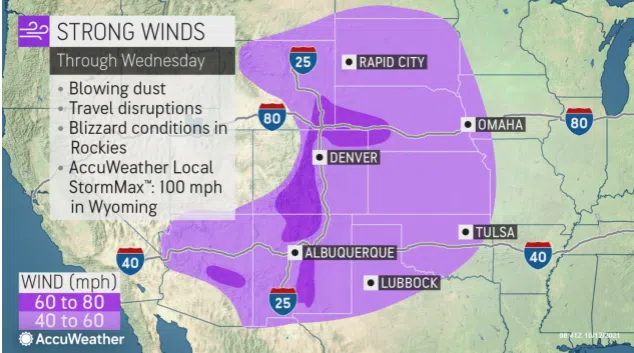
In addition to the feet of snowfall expected, blizzard conditions will be possible across central and eastern Wyoming as well. Wind gusts capable of reaching the equivalent of hurricane-force strength between Tuesday afternoon and Wednesday can not only whip the snow around but could also lead to fallen trees and damage to some structures.
As potential blizzard conditions whip snow along Wyoming’s Front Range during the day on Wednesday, the storm will begin to clear out in a west to east fashion across the Rockies. Although the snowy conditions will largely taper off, the wintry chill will continue in the wake of the storm across the West. This may give some ski resorts an additional chance to shake the rust off the snow machines and get them cranking in preparation for their respective opening days.
The reprieve from snowy conditions may be short-lived across the interior Northwest, as another quick-hitting storm may follow in the tracks of the early-week storm. At this time, AccuWeather meteorologists do not expect major snowfall accumulations from the next storm Wednesday night into Thursday.
( AccuWeather Meteorologist, contributed this report.)


